CITIES and TERRITORIES in the MIDDLE AGES in CALABRIA
The Byzantines with the definitive conquest of the Calabria after the greek-gothic wars (535-553 A.C.) have always operated in the strategic-military context, that is to defend and keep balances the territories, builted fortifications.
HISTORY HINTS - The Byzantines when arrived in Calabria (in the 536 a.D.) find two of the most important cities of Calabria, that is Reggio Calabria and Crotone without walls or others type of fortresses, so they built news one.
Note: by the chronicles of the Byzantine historian Procopius we know that the byzantines identify the cities protected by walls, because it created a community between byzantine official, soldiers and people.
.jpg)
....Other important medieval cities are Cassano allo Jonio and Rossano, born between the VI and the VII centuries a.D. after of the abandonment the roman city of Thurium.
HISTORY HINTS - The Byzantines when arrived in Calabria (in the 536 a.D.) find two of the most important cities of Calabria, that is Reggio Calabria and Crotone without walls or others type of fortresses, so they built news one.
Note: by the chronicles of the Byzantine historian Procopius we know that the byzantines identify the cities protected by walls, because it created a community between byzantine official, soldiers and people.
.jpg)
in red the important cities of Reggio Calabria and Crotone, for the Byzantines it were the most prestigious cities of the Calabria thanks to their ports and other economic interests.


 little stretch of the byzantine walls at Crotone VI century A.D., unique parts of byzantine walls remaining in Calabria of that time, the parallelepiped blocks come from greek walls (IV century b.C.).

Croton and its port


above images of Reggio Calabria

....Other important medieval cities are Cassano allo Jonio and Rossano, born between the VI and the VII centuries a.D. after of the abandonment the roman city of Thurium.

position

Cassano

Rossano
The first fortification work it happened few decades later with the arrival of the Lombards (596 AD), that tore the northen Calabria by control Byzantin, on this line were builded a series of fortresses communicating with each other by cutting the Region from tirrhenian until ionian sea (next figure).
.jpg)

The city of Cosenza was important in every age, becouse its natural position guaranteed protection and security.


VI century a.D. - In byzantine age other ancient cities continue to live thanks to their ports, among these Vibona, Tropea, Nicotera, Reggio Calabria and Crotone.


Up to here we have listed the most important calabrian cities in Byzantine and high middle ages.
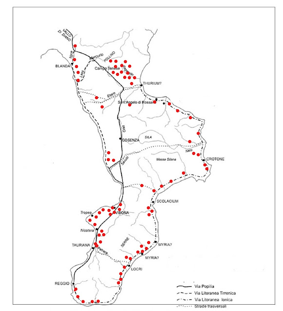
The fortified cornerstone arise as a control of the main road system, the ancient consular road (Annia-Popilia) is manned in the central-northen section, from the mouth of the Savuto to Morano.
The promontory that stretches out towards the sea, naturally defended, houses on its top the remains of the ancient Cerillae.
Cerillae was fouded by greek between VI and V century b.C., the Magna Graecia city was located on the coastal plain, but in the IX century A.C. its inhabitants moved to the heights to control the coast from the enemies.
Here they created an important fortified center.


The Piano della Tirena which since ancient age watched over the road that led inwards towards to Cosenza and the Crati's valley, probably as early of the IV century B.C. it been chosen as a place suitable for the controland defence of the coast, roads and also internal valleys.
In the early of Middle Ages (VI-VII century A.D.) the plateau is occupied by a fortified nucleus, its perimeter walls was reinforced by towers.


CONCLUSION: Inside the boundary walls after the Byzantine reconquest (end IX century A.D.), a church was also built.
To south from Piano della Tirrena we find another formidable fortress called Rocca Angitola, this fortress controlled the roads between the northern ando southern territories.


Fortified city was also Oppido Mamertina, founded by greek-roman people in IV century b.C. with the name Mamertion (cultors of god Mars), near to ancient city was builted a fortress which housed a military garrison.
In late ancient was called Oppidum referring to the previous fortress, the city was located on montainous plateau (figure below).


With the byzantine reconquest (IX century a.C.) the city was founded on remains of the ancient center with the name of Hagia Agathè, it was surrounded mighty walls and large castle.
IMPORTANT FORTRESS - At the tip of the strait find the fortress (for byzantines Kastellion) of Santo Aniceto X-XI century a.C., it was very important becouse it controlled the agricultural territory (rich in vineyards and mulberry trees to breed silkworms) behind the important city of Reggio Calabria.
It was strategic becouse controlled also the eastern part of the streit (figures below).


.jpg)
Limes: created at the end of the VI century AD, this line strarted from Amantea until to Rossano, the two cities were avampost military for the territorial control, especially the coastal plaines and the routes that led to the internal territories.
In this period was the Kastron of Santa Maria del Mare, built in the early of the VII century a.C., the fortified city is located near ancient Scolacium, in the lands belonged to Cassiodoro.


The disapparence of some ancient centers (V century A.D.) along coast and the progressive retreat on heights of the population, had to determine also desplacement of the roads that in many cases returned to trace within the territory, as the ancient muleteers.
This is case of the ancient Thurium, that nel V century A.D. it was abandoned definitively and its inhabitants moved at the Ruskianè's castle (Rossano), only the bishop with his clergy remained, but also it in VII century A.D. left the city and moved to Rossano.
 in blu Thurium and in black Rossano (first byzantine castrum in Calabria).

in red position of Kastron Santa Maria del Mare near ancient Scolacium

remains of the Kastron Santa Maria del Mare
The disapparence of some ancient centers (V century A.D.) along coast and the progressive retreat on heights of the population, had to determine also desplacement of the roads that in many cases returned to trace within the territory, as the ancient muleteers.
This is case of the ancient Thurium, that nel V century A.D. it was abandoned definitively and its inhabitants moved at the Ruskianè's castle (Rossano), only the bishop with his clergy remained, but also it in VII century A.D. left the city and moved to Rossano.


Rossano
The city of Cosenza was important in every age, becouse its natural position guaranteed protection and security.


the castle of Cosenza, located on the top of the St Pancrazio hill, it is built on an artificial rettangular Motta (embankment), whose orientation refers to the buildings of the Brutti or Bretii (VI B.C.)

the castle of Cosenza:
Probably the MOTTE of the castle was occupied by a Brettia fortress (VI-IV century b.C.).
Probably the MOTTE of the castle was occupied by a Brettia fortress (VI-IV century b.C.).

view of the city from castle

most important port cities:
Crotone, Reggio Calabria, Tauriana, Nicotera, Tropea and Vibona, with big black stars were important statio (I-V century a.C.) and in high medieval it were the fulcrum of the massae (vast agricultural lands, colorate in grey).
Crotone, Reggio Calabria, Tauriana, Nicotera, Tropea and Vibona, with big black stars were important statio (I-V century a.C.) and in high medieval it were the fulcrum of the massae (vast agricultural lands, colorate in grey).

view of Tropea

view of Nicotera
 view of Vibo Valentia:

the figure above show that the city already in greek age was located on areas higher compared from the coast.
Note: its harbour was located further downstream.
Up to here we have listed the most important calabrian cities in Byzantine and high middle ages.
The fortified cornerstone arise as a control of the main road system, the ancient consular road (Annia-Popilia) is manned in the central-northen section, from the mouth of the Savuto to Morano.
The promontory that stretches out towards the sea, naturally defended, houses on its top the remains of the ancient Cerillae.
Cerillae was fouded by greek between VI and V century b.C., the Magna Graecia city was located on the coastal plain, but in the IX century A.C. its inhabitants moved to the heights to control the coast from the enemies.
Here they created an important fortified center.

in red position of Cirella

remains Medieval Cirella
In the early of Middle Ages (VI-VII century A.D.) the plateau is occupied by a fortified nucleus, its perimeter walls was reinforced by towers.


profile PIANO DELLA TIRRENA

images above - natural plateau (terrace) of the fortress of Piano della Tirena, some historians maintain that the greek city of Temesa stoodon this rock.
CONCLUSION: Inside the boundary walls after the Byzantine reconquest (end IX century A.D.), a church was also built.
To south from Piano della Tirrena we find another formidable fortress called Rocca Angitola, this fortress controlled the roads between the northern ando southern territories.

ruins of ROCCA ANGITOLA

view from ROCCA ANGITOLA

this map show PIAN DELLA TIRENA (in red) and ROCCA ANGITOLA (in green)
Fortified city was also Oppido Mamertina, founded by greek-roman people in IV century b.C. with the name Mamertion (cultors of god Mars), near to ancient city was builted a fortress which housed a military garrison.
In late ancient was called Oppidum referring to the previous fortress, the city was located on montainous plateau (figure below).

engraving of Oppido Mamertina- 1699

position of Oppido Mamertina
IMPORTANT FORTRESS - At the tip of the strait find the fortress (for byzantines Kastellion) of Santo Aniceto X-XI century a.C., it was very important becouse it controlled the agricultural territory (rich in vineyards and mulberry trees to breed silkworms) behind the important city of Reggio Calabria.
It was strategic becouse controlled also the eastern part of the streit (figures below).


Santo ANICETO

in red Reggio Calabria and in blu Santo Aniceto
 particulary of the strait, point in blu the position of Santo Aniceto

wonderful my Calabria!!!!!!!!!!!!
Dott. Giuseppe Lombardo


Commenti
Posta un commento