MEDIEVAL ROUTES in CALABRIA
The ports and terrestrial viability were indispensable for the economy of the Roman Empire, above all in late ancient age (III-IV century A.D.) to export the agricultural productions of the rural territory.
In the Late Ancient (II-III-IV centuries a.C.) the landscape of Calabria was dotted with roman productive villas, especially in the coastal areas of the Region, some of them survived until the VI century a.C..
This system of villas was located near important roman cities, to sell the agricultural and artisanal products in these cities markets, related at large coastal arterias (pubblicae) and near at rispective ports, for export of goods to other parts of the Mediterranea sea.

On these roads and near villas were built great termae (thermal environments), it were places of socialization and decisions of development of the areas, but also activies among influential local nobles/senators and politicians.

In the Late Ancient (II-III-IV centuries a.C.) the landscape of Calabria was dotted with roman productive villas, especially in the coastal areas of the Region, some of them survived until the VI century a.C..
This system of villas was located near important roman cities, to sell the agricultural and artisanal products in these cities markets, related at large coastal arterias (pubblicae) and near at rispective ports, for export of goods to other parts of the Mediterranea sea.

points in red: known roman villas scattered in the coastal agricultural areas.

Graphic reconstruction of late ancient villa, the covers in yellow are the thermal baths.
(figure by basilicataturismo.it)
NOTE - The Calabria in these centuries was still governed by a central power (Roma), where there care of the roads was the main practice to ensure fast connection between the different territories, so the economy in the last temporal period of the Roman Empire was still prosperous and facilitated by these comfortable roads.

in red Roman Roads (pubblicae), in blu most important Roman port cities in Calabria
On the roman roads, in addiction to luxurios villas there were important stationes and thermal complex made by great owners/nobiles (figure below), when the Roman Empire disappeared in V century a.C. the streets were not maintained, so went slowly in ruin.

stationes/mansiones/mutationes: roman cities site along roads with structures (hostel/refuge) suitable parking facilities for man and animals, tabernae (taverns), place to buy the service of carters ferriers and veterinarians (equarii medici) specialized in horse care.
In short, for the Romans were places of service for travelers, also a rest area for the Imperial officials of the bureaucracy.
In short, for the Romans were places of service for travelers, also a rest area for the Imperial officials of the bureaucracy.

ruins of a thermal complex near a monumental roman villa (?) and probably near an important city, it was located on the important consolar road via Annia-Popilia, belonging to who at the time ruled half Calabria in the IV century a.C..


The great thermal complex is rapresented on the Peutingeriana table (XII century A.C.) copy of a roman map with name Aque ange.
In this imposing stucture there was a gym and other recreational activies.
Even the disappearance or moving on other sites of important coastal cities between VI and IX centuries a.C., was even more decisive in the ruin of the previous road system, especially along the ionian coast.
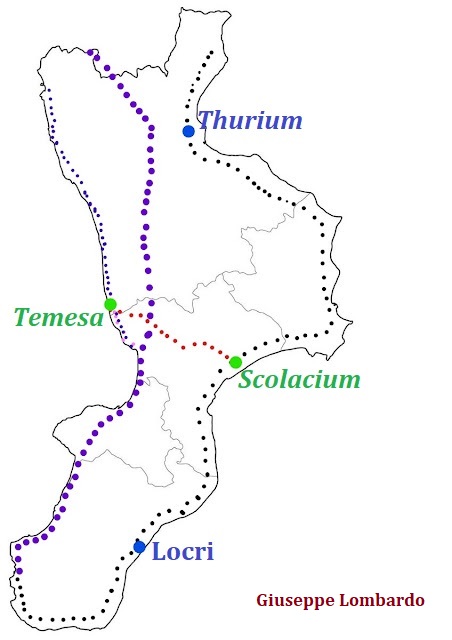
The other roads already practiced in ancient age were also the isthmic road between the city of Solacium and Temesa, which from the ionian coast linked to great consolar road Annia-Popilia, it was a fundamental link between the different calabrian sub-regions, and as it was always used even in all the Middle age and in some ways still today, again today is a important road (figure below).
Preamble: The previous Roman road axis in Calabria was still used in the VI century a.C. by Generals in the greek-goth wars, to have a rapid movement of the troops.
The great consolar Annia-Popilia was used by the Longobards (595-596 A.C.) to reach Reggio Calabria, during the middle ages (VII-XII century A.C.) some sections were kept efficient, especially near important port cities.
In 535 A.D. arrived the Byzantine to oust the Goths from Italy, therefore until 553 A.D. the italian territory became a battlefield.
The other roads already practiced in ancient age were also the isthmic road between the city of Solacium and Temesa, which from the ionian coast linked to great consolar road Annia-Popilia, it was a fundamental link between the different calabrian sub-regions, and as it was always used even in all the Middle age and in some ways still today, again today is a important road (figure below).

Previous roman viability in Calabria: punctuated in purple consolar roman road Annia-Popilia, punctuated in black roman ionian coastal road, in red isthmus road.
HIGH MEDIEVAL AGE
Preamble: The previous Roman road axis in Calabria was still used in the VI century a.C. by Generals in the greek-goth wars, to have a rapid movement of the troops.
The great consolar Annia-Popilia was used by the Longobards (595-596 A.C.) to reach Reggio Calabria, during the middle ages (VII-XII century A.C.) some sections were kept efficient, especially near important port cities.
In 535 A.D. arrived the Byzantine to oust the Goths from Italy, therefore until 553 A.D. the italian territory became a battlefield.
The Byzantine with the general Belisario landed in Reggio Calabria in 536 a.C., here won a battle against the Goths, managing to open the way to the north of Calabria and Italy.
The disappearance or relocation on other sites of important roman coastal centers between V and VI centuries a.C., was even more decisive in the ruin of the previous road system, especially along the ionian coast.
The other roads already practiced in Ancient Age were also the isthmic road between the city of Scolacium and Temesa that from the Ionian coast linken to the large Road Annia-Popilia, was a fundamental link between the different Calabrian sub-regions, and as such it was always used even in the Middle ages and in some ways still today, as today's road follows the same direction (figure below).

The other roads already practiced in Ancient Age were also the isthmic road between the city of Scolacium and Temesa that from the Ionian coast linken to the large Road Annia-Popilia, was a fundamental link between the different Calabrian sub-regions, and as such it was always used even in the Middle ages and in some ways still today, as today's road follows the same direction (figure below).

punctuated in blu ancient Ionian coast road and in red isthmic way road between ancient cities of Scolacium (Squillace) and Temesa (great points in black).
The Ionian coast road that connected Taranto to Reggio Calabria, is attested by the byzantine chronicler Procopius during the greek-gothic wars and is stil remembered in XII century as Via Publica or Magna Strata.
The Consolar road Annia-Popilia in VI century A.C. was still practiced by pilgrims, then between the VII and X century A.D. we don't have other oral or writen notices of those who pacticed the great Annia-Popilia road.
In high Calabria the great Anna-Popilia near Cosenza it forks, and along coastal tirrenic road in IX century it used by the Arabs, to carry out their raids (figure below).


 profile PIANO DELLA TIRENA
 Photo from the high of PIANO DELLA TIRENA, wow!!!!
(Foto by noceraterinese.it)
In XII century A.C. the byzantines pilgrims for to go in Rome to visit the Christian place, as the tombs of St. Pietro and Paolo landed at the important port of Crotone.
From Crotone the pilgrims crossed the coastal road (in black) until the Crati valley, and from there they entered in the great consolar way Annia-Popilia (in red) to continue in a northerly direction (figure below).

 position Crotone

 port of Crotone in an arab map of the XII century
In the southern Calabria we haven't ancient descriptions written or oral on roads and passages between VII and X centuries A.C., we know only that since X century A.C. the important byzantinian cities (Kastra) of Gerace and Stilo controlled the internal passageways and the underlying valleys.


NOTE: in the Middle Age, churches and convents located on important routes took the place of the ancient roman statio, above all in welcoming pilgrims.
EXAMPLE: The important roman statio of Interamnia, in middle age it became important resting place for pilgrims who reaced Campania or Basilicata (figure below).

In high Calabria the great Anna-Popilia near Cosenza it forks, and along coastal tirrenic road in IX century it used by the Arabs, to carry out their raids (figure below).

punctuated in light blu the coastal strip Annia Popilia and in red the internal way of Annia-Popilia
MIDDLE AGE
Tanks to an economic revival that could be seen in X century a.C., the byzantines restored and maintained the ancient road Annia Popilia as efficient as other inland routes (P. Dalena), then the Normans used it again to start the conquest, in fact in all the centers gravitating on the road were equipped with fortresses.
The Normans in XI century arrived in Neocastron important byzantine city in lametina plain, here in 1057 A.C. they built a large military manor on a previous Byzantine fortress from there they controlled a strategic road route in the different directions, which allowed them to reach and conquer Squillace (figure below).
isthmic way: road connecting the important byzantinian cities of NICASTRO and SQUILLACE


Neocastron (Nicastro -Lametia Terme), at the top of the centre there are the ruins of the norman castle.
(foto by Valentino De Gennaro)
Norman castle of Squillace, built on a previous byzantine fortress
(foto tratta galserrecalabresi.it)
OTHER SITES
A very important stretch at the center of important connection between northen and southern Calabria is the road junction controlled by Piano della Tirena, a plateau overlooking the Thyrrenian coast where from its heights since ancient age it was possible to control the most important roadways land.
The plateau controlled the coastal road that went north, the roads that led into Crati valley to Cosenza, and finally the road that led south to the ancient statio of Angitola north Vibo Valentia (figure below).
Since High Medieval age it was a fortified site, in fact since the Greek-Gothics wars it was used for strategic territorial and control porposes. Finally in the last phase byzantine (IX-X Century) a monastery was built.
Since High Medieval age it was a fortified site, in fact since the Greek-Gothics wars it was used for strategic territorial and control porposes. Finally in the last phase byzantine (IX-X Century) a monastery was built.

in red PIANO DELLA TIRENA, in purple COSENZA and in green statio of ANGITOLA


(Foto by noceraterinese.it)
In XII century A.C. the byzantines pilgrims for to go in Rome to visit the Christian place, as the tombs of St. Pietro and Paolo landed at the important port of Crotone.
From Crotone the pilgrims crossed the coastal road (in black) until the Crati valley, and from there they entered in the great consolar way Annia-Popilia (in red) to continue in a northerly direction (figure below).

punctuated in black ionian coastal road and punctuated in red stretch of Great ancient way Annia-Popilia.


Crotone and its port

In the southern Calabria we haven't ancient descriptions written or oral on roads and passages between VII and X centuries A.C., we know only that since X century A.C. the important byzantinian cities (Kastra) of Gerace and Stilo controlled the internal passageways and the underlying valleys.

in blu Gerace and in red Stilo very important medieval cities, connected to tyrrhenian cost by internal roads.

GERACE

STILO
 Stilaro valley, view from Stilo
(foto by maimonecommunication)

(foto by maimonecommunication)
NOTE: in the Middle Age, churches and convents located on important routes took the place of the ancient roman statio, above all in welcoming pilgrims.
EXAMPLE: The important roman statio of Interamnia, in middle age it became important resting place for pilgrims who reaced Campania or Basilicata (figure below).

position of Interamnia
Calabria is a wonderful land rich in treasures!!!!!!!!!!!!!
see you soon💗
see you soon💗
Dott. Giuseppe Lombardo


Commenti
Posta un commento